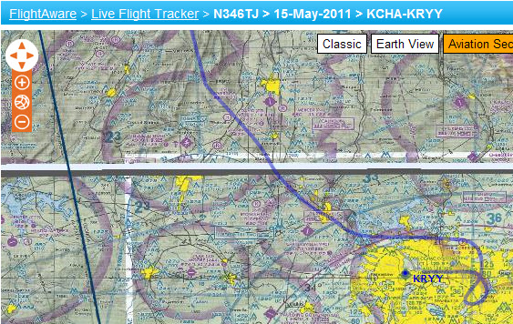
Landing in a Snowstorm

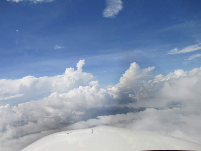
This week I had a really unusual flight.  It started out as a simple VFR takeoff in clear blue skies.  I was bringing the plane home to Poughkeepsie from maintenance in Danbury.  Simple, short flight… Or so I thought…  This was me in the hanger just before takeoff:

But the weather forecast looked a little sketchy.  There was a squall line filled with snow and high winds west of Poughkeepsie.  My weather briefing led me to think I could easily land in advance of that squall line reaching the airport.

Wow… Was I ever wrong.  When I was ~ 15 miles out from Poughkeepsie, the tower controller told me conditions were deteriorating fast and the airport was going IFR.  From there, things continued to get harder and harder.

First, while on ~8 miles out on the RNAV GPS 24 approach to runway 24, I had to get a “popup IFR clearance” from NY approach.  Then, I had to declare a missed approach.  This was my first REAL missed approach because I could not see the runway when I reached minimums on the RNAV 24.

But the squall line was moving fast, and I thought I could just hold at the missed approach point and then try it again.  The second time worked … But it was quite possibly the toughest landing I have ever done!   In fact, after I landed, I just stopped on the runway for a few minutes because I couldn’t see the taxiways.  During the whole experience, I had cameras rolling … So you can see and hear for yourself in the video below:

After reviewing the footage, I realized how important it is to always be ready to go missed and the practicing proper IFR procedures.  I didn’t do this one perfectly… (You might see a couple of my mistakes in the video… including flying the missed by hand instead of autopilot).  But I sure learned on this flight!!

Cheers,
== T.J.==

Simple, Short Flight Turns into More

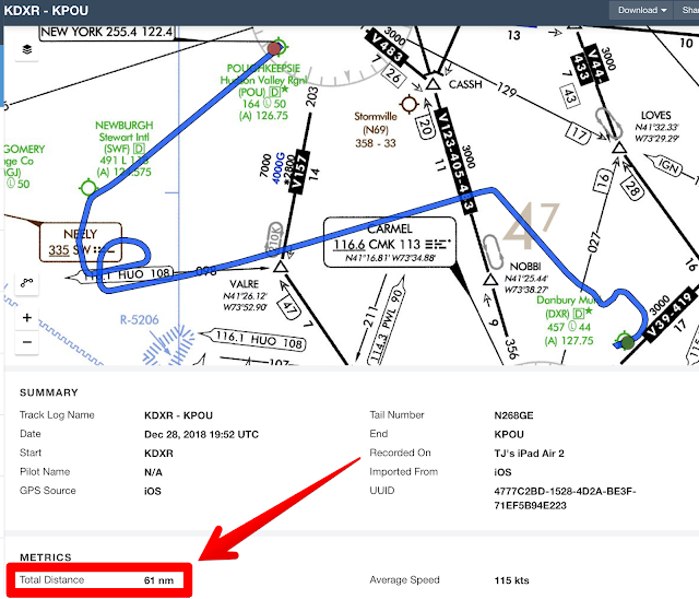
Today, I wanted to pick up the Cirrus from my mechanic after some routine maintenance.  The plan was a VERY simple 24nm flight from Danbury, CT to Poughkeepsie, NY.  You can see the planned route below:
But the weather wasn’t very good … Not terrible, not dangerous, just light rain and low ceilings in both DXR and POU.

Shortly after takeoff, I climbed to ~ 1200 FT and entered the clouds.  From that point on, I found the skies and the NY Approach ATC frequency busier than ever.  Due to other commercial traffic, I got a couple of vectors and reroutes… But eventually, I made it to Poughkeepsie.  where the weather was a little worse than Danbury:
Luckily, POU is a fantastic airport with lots of instrument approaches.  I came in on the RNAV GPS 06, which had an LPV minimums of 503 FT.  Luckily I broke out of the clouds @ ~ 560 FT and was greeted by a runway that was lit up like a Xmas tree!  This turned out to be the perfect real world use case for the amazing Perspective Plus avionics in the new Cirrus!!

You can see what I saw from the cockpit in this short video:

So in the end, the simple, straight 24nm trip, turned into this:
After this flight, I am really starting to feel comfortable with the new avionics!

Stay tuned as I have many more flights/videos coming on My New Youtube Channel !

Cheers,
== T.J.==


Finally The Storm Has Passed

Tropical Storm Debby finally passed most of the state of Florida yesterday!

I was very disappointed that I couldn’t continue the seaplane training this past weekend.  Worse yet, the seaplane base is closed next weekend due to the Brown family vacation!  So that will need to wait till sometime in July.
After 3 days of not even seeing the sun, I decided to do a “normal” IFR flight to Ft Lauderdale.  The weather at both the departure and the destination looked reasonable .   But there were a couple of pesky lines of weather in the middle.

Luckily, TS Debby was further north and weakening.  As such, winds aloft were only between 20 and 30 knots.
But I definitely had to work with Miami  ATC on several deviations along the way.  Usually my weather deviations tend to be laterally 10-20 degrees.  But today my track felt like a zig zag laterally and also had to change altitudes multiple times due to the military airspace in the area.
Most of the flight was totally smooth.  But I did have to bounce and weave through the one line, which you can see below:
The weather on screen, was about 6 minutes old.  So the route on the screen looks crazy.  But the real clouds out the window had a nice break at ~ 6000 Ft and looked MUCH nicer!
After getting to the “other side” of the line, it was totally smooth sailing the rest of the way!
Dealing with the weather, and a very busy Miami Center on this trip, turned out to be a good practice flight in advance of next week’s big IFR journey to the Cirrus Migration event!

Cheers,
== T.J.==

State #49 (New Mexico) and Vegas

After spending entirely too much time in China during the past month,  I was finally able to squeeze in a good IFR x-country trip.  There was a meeting in Vegas that I wanted to attend and conveniently New Mexico was sort of on the way 😉

The routing was fairly direct, as you can see below:

I could  have done the journey with 2 stops.  But instead, I chose an extra halt so that I could stop @ familiar places where I knew the FBO hospitality was good and the gas was cheap.  Both TVR and DUA fit that purpose.
 
Along the way, the weather was perfect… Well almost perfect… Most of the journey was clear, blue sky.  However, there was one line of ugly weather that I had to cross.  As you can see below, there was just no good way around it.

So I used all of the enroute weather info I could get from ATC, Flight Service and the onboard  R9 weather.  Then I used the vector mode of R9 to dodge and weave through the line.
In the end, I encountered only moderate rain and light chop.
Aside from that brief weather encounter, the rest of the journey till New Mexico was uneventful. 

As far as New Mexico, I wanted to land somewhere in the northern part of the state so that it wouldn’t be too far out of the way.  So I decided to stop @ Tucumcari, NM.  It was a rather spartan airport with quite a bit of construction going on.  But it was still a good rest stop and more importantly the official 49th state! 


After NM, the final leg to Las Vegas turned out to be the truly memorable part of the trip for a couple of reasons.  

First, I was able to fly directly over the Grand Canyon, which is a restricted special flight rules area.  This was due to a friendly ATC controller from Denver Center who was willing to work out a clearance for me.  The views were awesome!  You can see some of the pix in the album below:

The second reason this leg was memorable was the “excitement” of the approach into Las Vegas.  When I was ~ 30 miles out, I requested the GPS 30L approach to North Las Vegas.  ATC was quite busy and basically said “NO… Go Away”.  In fairness, ATC was a bit more polite than that, and since the weather was clear, I was not concerned.  But the troubling part was that ATC wouldn’t give me a clearance to descend until the very last minute.  I was ~ 12 miles away from the airport and still level @ 10,000 FT!
At that point, ATC asked me “IF cleared for the visual approach to 30L via the left downwind, could I make it without having to do a 360″.  With the most confident radio voice I could muster, I said “Affirmative”.  After ATC gave me the official clearance, I pulled the power to idle, applied full right rudder and did what felt like a “nose dive”.  With a descent rate of ~2000+ FT/Min I aimed for the midfield point of the left downwind!
While I have practiced emergency descents before, this was the first time it felt real. I was at idle power almost the entire way to a full stop landing!  Unfortunately, it happened so quickly, I didn’t get a chance to setup the cameras to capture the amazing view of the strip as you land.
In fact, when I was on final, I contemplated declaring a missed approach just so that I could circle around and take some pics… But I decided not to, thinking that might be a bit rude to ATC 😉  
 
Next time, I guess I will need to setup the cameras before takeoff!

Cheers,
== T.J.==

Tough Start To A Very EZ Journey

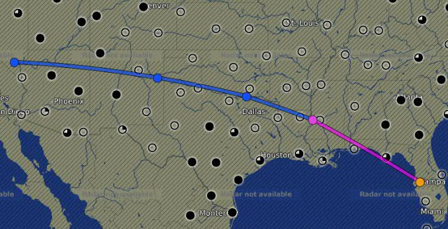
This week’s mission was to go from Tampa,FL to Danbury, CT, which is a perfect mission for an SR22 with one fuel stop.  
 
Surprisingly, the weather forecast was beautiful everywhere along the route except Florida.  Usually, it is the other way around.  So I was expecting a takeoff in moderate / heavy rain, which is OK.  (I don’t mind rainy takeoffs.)  But I was dreading the preflight in the rain.  
 
I left the plane in the hanger while I did all the usual checks.  At this point, one of the Tampa Exec line guys (Nathan), really went out of his way to help me and made the preflight as good as it could have gotten under the circumstances. 

After fuel and oil, Nathan towed me out of the hanger with me sitting nice and dry in the cockpit! Just when I thought the service couldn’t get any better,  Nathan parked my car in the hanger, closed the hanger door and brought me my keys!!!

As I sat in the cockpit getting ready to startup, I was feeling really spoiled. 

Then a dose of reality struck…

While trying to start up, I must have used a bit too much primer and flooded the engine.  Ugh!!

As I have mentioned before, starting an SR22 is a bit of an art.  Even after a 1000 Cirrus hours, I still feel my starts are less than elegant.  Usually, it is only tricky with hot starts….But for the first time, I screwed up a perfectly normal, cold start.

After waiting ~ 20 mins, I tried again with much better results.  The plane growled and came to life right away!

The takeoff was exactly as advertised on the ATIS, which meant heavy rain, low ceilings and a generally bumpy climb out. 

Since I already posted a very similar YouTube video of a rainy takeoff, I didn’t even bother setting up the video equipment this time.

During the climb-out, the weather onscreen looked awful:

But by the time I leveled off @ 17000 FT, I was above all the rain and clouds.  The rest of the trip to NC was totally smooth with not a single cloud or bump!  In fact, ATC was so quiet, I did a few radio checks just to make sure the radios were working.  I could have really used a flight attendant serving drinks and an in flight movie 😉

As I approached Duplin County, the Wilmington Approach ATC controller also went out of his way to help me.  He asked ” Where was I going after getting fuel @ KDPL? And did I want an onward clearance?”
 
This shocked me! He gave me a full clearance, including a squawk code and a frequency for my second leg.  I thanked him, cancelled my flight plan, and made a very easy landing in NC in calm winds and 10 miles visibility.
 
After fuel and a quick turn, my next leg was even smoother and in clear, blue skies.
Washington center laughed at my direct routing and gave me  a typical Northeast clearance with 3 victor airways and 6 fixes.  Luckily it was close to a direct routing and the weather was so nice, I didn’t notice the time go by.
As I was getting close to Danbury, I got some great views of the Hudson River and even the IBM office in Somers, NY, which you can see below:

IBM Somers Office

So what started out as a tough journey ended up being extremely easy!
The weather forecast does not look as promising for the trip home … 

Hmmm… Might need to take a creative detour home!
 
Cheers,
== T.J.==

Fuel Planning Over The Gulf

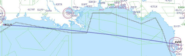
Last weekend was a perfect example of why you must “get good” at flight planning while enroute.

I planned a simple direct flight over the gulf at 16000 FT from Tampa, FL to Galveston, TX.
Conventional wisdom says you do your flight planning on the ground and then simply execute in the cockpit.  It sounds simple … But that rarely seems to work for me.  There are frequently “surprises” enroute that I never seem to be able to predict in advance.

The flight planning on the ground looked quite promising.  The weather was clear and the winds aloft were quite tame along the route (210@10kts)  According to my calculations, the flight should have taken 4hours 9 mins.  This would allow me to land with comfortably more than 1 hour and 51 minutes of fuel to spare, which is about 30 gallons.

Since the weather and fuel looked good, I began my usual preflight.  However, because  this was a flight over the Gulf of Mexico, I took a couple of extra precautions.  First, I made sure my lifejacket was within easy reach. Second, I made sure my Personal locator beacon (PLB) was in my pocket and ready to go.

Shortly after takeoff, things started to change.  Tampa approach was dealing with a lot of traffic in the class B. As a result, my clearance was a bit inconvenient with a heading of 090, followed by several painfully slow heading changes before I was heading westbound. After I leveled off @ 16k FT, I rechecked the fuel projections on R9 and found it predicting 25 gals @ destination.

No problem… (My personal minimum is anything greater than 20) … So far so good …

Then Miami center said the dreaded words “We have an amendment to your routing, advise when ready to copy”.

Uggg… The new routing was direct Seminole (SZW), direct Crestview (CEW) direct destination.

After refreshing the fuel calcs in the R9, it showed 19gals @ destination… This was not good! I have read so many accident/incident reports where pilots “stretched” personal minimums only to realize later that this was part of the accident chain.

I decided if it didn’t improve above 20 by 1 hour from destination, I would divert.  But I still had plenty of time.  In the meantime, I reduced power to 65% to try to conserve fuel.

After about 20 mins, I found myself in and out of a thin cloud deck and facing increased headwinds (240@33).  No immediate danger… But fuel status was now getting worse and the R9 was now predicting 14 gals @ destination.

So I pulled up Foreflight on the iPad and started looking for a place to divert in Louisiana. In addition, I reduced power further to 60% to conserve even more fuel.

I also tried to be clever and “use ATC’s help” to conserve fuel.  Every time I got handed off to a new ATC controller, I asked for “a shortcut of 10 to 20 degrees.  This worked remarkably well.  Before I knew it, the R9 was predicting 21 gals@ destination!

But my optimism was short-lived.  The headwinds picked up to 244@42kts.

Now the R9 showed 18 gals @ destination 🙁

That did it, time to divert… Houma,Louisiana looked like a good spot.  I told myself 50 miles from Houma would be the decision point to change my IFR flight and start a descent.

Miraculously the winds died down before then and I was able to press on to my destination.

When I landed in Galveston, the R9 reported 20.7 gallons remaining! phew!!

I parked right next to a beautiful Citation CJ2 and a friendly lineman, named Eric, rolled out the red carpet for me!

After a wonderful flight, I am more convinced than ever, that flight planning enroute is an even more important skill than planning on the ground.

Thank goodness that there are cockpit gadgets that let us do that!

Unfortunately, with all the fretting over fuel, I forgot to take pictures!!

(Have to make up for that on my next flight)

Cheers,
== T.J.==

Long X-Country, Weather and State #38 (AZ)

This weekend I had a long cross country flight planned.  The destination was Sedona, AZ, which is a very famous airport for pilots. 

According to the Sedona Airport website, they claim to be “America’s Most Scenic Airport”.  It is also sometimes referred to as the “USS Sedona” because it feels like landing on an aircraft carrier.  This is due to the fact that the airport is situated on a Mesa with a 500 FT dropoff on both ends of the runway. 

To add further drama, Sedona is home to a number of “spiritual vortexes”, which are clearly identified on tourist maps.  In fact, one of them is right on the Airport access road.  Some say that it may even contribute to the bizarre wind patterns that pilots wrestle with on final.
The first leg from Tampa to Shreveport was a grueling battle with weather.  You can see from the screen shot below why I had diversion clearances of 20 degrees right or left most of the way.

Luckily after Shreveport, there was no more rain to contend with.  The next stop was supposed to be Truth or Consequences, NM.  I thought the name was unique, and their runway layout even more unique.  But as I was flying over West Texas, I needed a break.  So I pulled out the iPad and found a great little airport in Snyder, TX that was only 40 miles from my position and had cheap fuel, internet and a crew car!

Since I was on an IFR flight plan, I called ATC and told (not asked) to divert to Winston airport (KSNK).  Their immediate response was “WHY???”.  I replied “NO emergency… Just change in plans”.  Then I did a couple of 360s to get down from 16,000 FT and had an uneventful landing.  The crew at KSNK (Ray and Danny) were extremely friendly and helpful.  After a bite and a bunch of “hanger flying” with the crew, I was ready for departure. 

However, it was 95 degrees out and I struggled with the hot start.  After 2 failed attempts, I pulled up Alex Wolf’s YouTube video on SR22 hot starts and that did the trick. (Thanks Alex!!)

Now I was finally direct Sedona.  As I approached, I instantly understood why this airport has so much hype. The views were breathtaking!  I tried to capture some of it on video, which you can see below:


So Arizona is now officially state # 38 and because of my little detour, I will try to hit New Mexico on the way home.

Cheers,
== T.J.==

Holding Pattern Without A Shuttle View

As everyone knows, today was the day for the space shuttle’s last mission.  I didn’t have tickets to see the launch in person.  But I really wanted to see it.
So I came up with what I thought was a clever plan.  I would fly the Cirrus upto 17,000 FT and go into a holding pattern “near” the launch site.  Of course, “near” meant I had to stay clear of the TFR (temporary flight restriction), which was a 30 mile ring around the launch site.  That would still give me a memorable view and hopefully even some pictures/video.
Unfortunately, this plan didn’t quite work as I had hoped…
The weather in FL was lousy today!  Not as bad as a hurricane or a convective sigmet.  But plenty of clouds, rain and lots of dreary overcast.
Ever the optimist, I filed an IFR flight plan and decided to try it anyway.  I was hoping to get above the clouds where I could get a view.
When I filed the IFR flight plan, I wrote “Training flight: practicing holding patterns @ COKES” in the remarks section.  COKES is an intersection just off the FL east coast near Flagler County airport that was just outside of the TFR.
When I arrived at the airport, I did my preflight inspection under some very nasty looking clouds, which you can see below:
As luck would have it, as soon as I finished my preflight and closed the door, it started raining!

As I waited for my IFR clearance, I watched another Cirrus land in the rain.  I checked all of the avionics one more time and then was ready for takeoff.  Taking off in the rain is bit unusual because there is really not much to see out the window and you have totally rely on instruments moments after rotation.
After I was airborne, the next hurdle was ATC.  They were quite busy today due to the weather and several other aircraft maneuvering to do the same thing as me.  Initially, they only cleared me to 5,000 FT, which was right in the middle of a cloud layer.  Aside from the training/practice value, this was rather unsatisfying.  There was absolutely no view and it was so bumpy I couldn’t even play with any camera equipment.  I asked 3 different controllers for a higher altitude.  Each one told me to “standby” then later said “unable” due to traffic or some other excuse.
Finally, I got handed off to the Daytona Approach control, where I encountered a much more cooperative controller.  Despite my “disguised” flight plan, he knew exactly what I was doing and was eager to help.
He gave me a clearance to 10,000 FT and told me to hold over Ormand Beach Airport.  I happily complied and setup my cameras.  Unfortunately, even @ 10,000 FT, there were too many clouds to see anything.  ATC was unable to clear me any higher due to “inbound international arrivals”.
So after all the effort, I didn’t see or even hear the launch!
But the trip was definitely not over.  I still needed to fly home and the weather continued to add drama to the trip.  You can see both the TFR (with the RED ring) and the weather in Tampa on the screen shot below.

The rain was fairly heavy and I flew the GPS23 all the way down to 450 FT before I could even see the runway!  As I got to the runway numbers, I realized I was a little high.  Since the runway was longer than I needed, I just floated a little and landed slightly long…. You can see for yourself in the video below:
After I got home, I finally watched the launch on CNN…  Even though I didn’t see it live, I got some great weather flying experience today!

Cheers,
== T.J.==

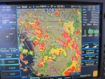
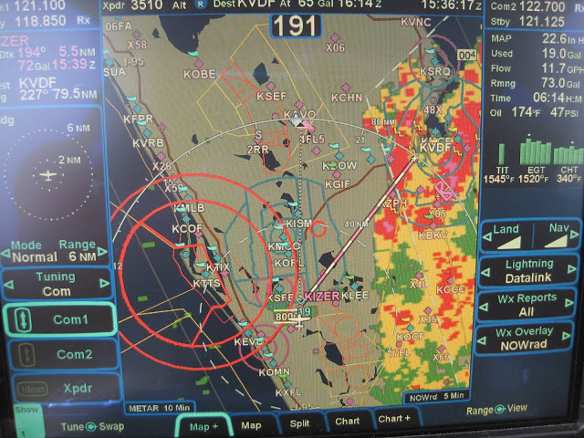
State #37 (NE) and Missouri River Flooding

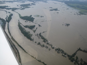
On the way back from Sioux Falls, the weather once again played a factor in my route.  I needed to leave SD before the storms arrived and I was also hoping to hit one more state on the way.
I was heading to Lexington, KY and found a routing through Omaha that worked perfectly:
On the way to Omaha, I noticed a very unusually shaped TFR (temporary flight restriction), which is the red outlined area in the picture below:
At first I wasn’t sure what to make of this …. Then I realized that this TFR was over the sections of the Missouri River that were experiencing some major flooding.  The TFR was surface to 4000 FT.  I overflew most of it and saw how just how bad it was first hand:

Omaha, which is right on the Missouri River near the Iowa border, was also affected by the floods.  The airport was still open despite flooded areas adjacent to several taxiways.
After landing, I jumped into a crew car and headed to the Hollywood Diner.  It was simple, regular diner food.  But it did have some unusual decor.  The whole place is decorated like a 1950s diner with tinsel town memorabilia in every wall, ceiling and corner.

The final leg of the journey was from Omaha to Lexington.  This part of the journey was smooth and uneventful.  Even had a moderate tailwind most of the way.
Cheers,
== T.J.==

Training Mission Accomplished!

This past weekend was fun, educational and downright grueling!  As expected, the ground portion of the CPPP covered some specific topics, like in-flight weather, engine management and aviation safety.  The stats around Cirrus accidents and parachute deploys were quite a surprise to me.  However, the flight training was the really significant part for me this year.
The instructor I was assigned (named Cliff) was a former military pilot and a very seasoned instructor. I had met Cliff a few months ago.  But never had the opportunity to fly with him before.
The plan was to cover VFR work on Saturday, such as stalls, slow flight, unusual attitudes, emergencies etc and IFR work on Sunday, such as procedures, holds, precision flight etc.  Sounds simple right??.  (That’s what I thought)
From the beginning, Cliff’s military background was blatantly obvious. After he carefully watched me do the entire pre-flight, we taxied out to runway 27.  Seconds after we started to move, Cliff noticed I was a few inches off of centerline and ~ 1200 RPM.  He immediately insisted that I get “exactly on centerline” and “exactly @ 1000 RPM”.  That was just a hint of the level of precision that Cliff demanded of his students.  After the run up, he gave me the instructions for the flight and we were quickly cleared for takeoff.
After departure I was to join V97 as soon as practical and track to the Rome VOR using NO GPS and NO AutoPilot.  The “no auto pilot”, I expected… But the “No GPS” hurt.  I felt like I couldn’t use any R9 magic and I don’t remember the last time I tracked a radial to an old fashioned VOR!
After I eventually got to the Rome VOR, we did some slow flight, stalls and unusual attitudes. Again, I thought to myself “Simple enough”. However, I didn’t realize the level of precision he required.  As a result, it took me 4 attempts to do one of the maneuvers until I did it “well enough” for him.  Even his technique for simulating emergencies was a bit interesting.  He pretended to be a panicked passenger repeatedly yelling “Smoke in the Cabin” when we were ~ 5 miles from landing.  I had to retrieve the right checklist and stay focused despite his distractions. After surviving Saturday, I was looking forward to Sunday’s IFR flight because that is more of my comfort zone.
On Sunday morning, I was prepared to spend the entire flight under the hood.  Luckily (or unluckily) the weather was not very good and most of the flight was in actual IMC.
My level of precision was more to Cliff’s liking on Sunday 😉  I was doing great and feeling rather proud of myself for flying so well in the clouds.     Then Cliff decided to change everything!
1. First, he blanked out my PFD, which is the left IFD screen on the R9 … (No problem… I just flew while looking at the right screen.)
2. Then he pulled the autopilot circuit breaker… (No problem… I just flew by hand..)
3. Then he pulled the circuit breaker on FMS keyboard … (No problem.  This was the first time I flew with this many things “failed” at the same time… But I did reasonably well)
4. Then he told me I had to fly the ILS27 back to McCollum Field in this condition… Yikes!  Just flying straight and level in this condition was OK.  But flying an ILS in actual IMC with 3 items failed, really pushed me!!!  I struggled to keep up with the radios and frequency changes using only backup instruments.
Fortunately, both Cliff and I survived!  Here is what the resulting GPS track looked like on Flightaware:

After a short break, I flew home and finished the weekend with ~ 10 hours on hobbs and a huge feeling of accomplishment!  Hopefully, I wont have to experience any of those emergencies for real.  But if I do, I now feel just a little more “ready”.
Cheers,
== T.J.==