Landing at JFK

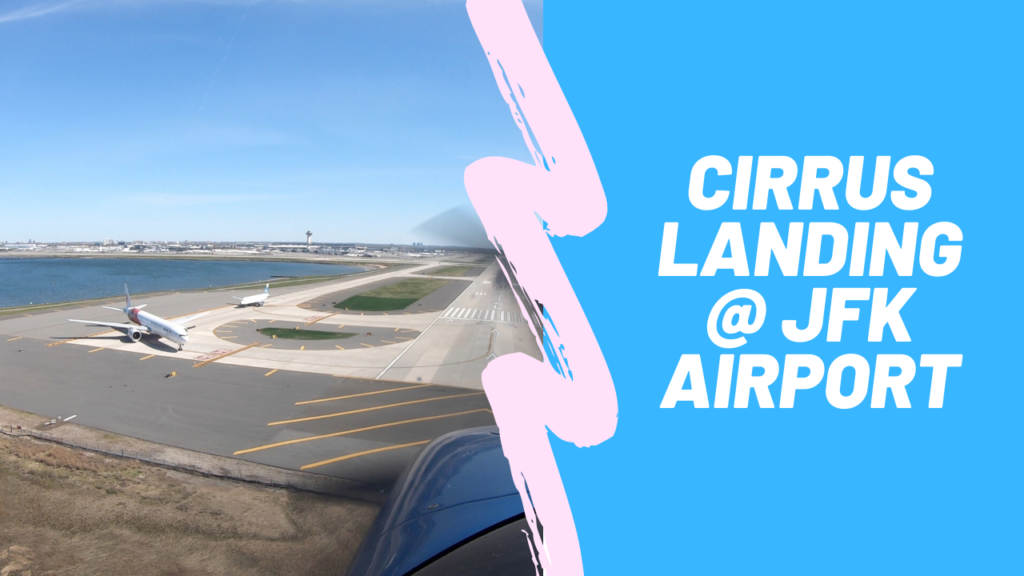
As some of you know, a couple of weeks ago, I tried to do a “Touch & Go” at JFK.  I figured that due to Covid-19, the skies would be pretty empty and ATC would have plenty of time on their hands.   That attempt did not work 🙁 The controller told me “Touch & Gos” were not allowed @ JFK without prior permission from the Port Authority.

So this past week, I decided, I would try to get permission.  I didn’t really know who to call.  So I started my research by looking up the JFK entry in the FAA Airport Facility Directory.   The first line of the comments stated that JFK was a “Part 93 High Density airport”, which means it had special rules.  But it didn’t state what the rules were.  It did have the phone number of the airport manager.  So I just called and asked.  He told me to talk the manager at the control tower and gave me that number.  When I spoke to the Control tower, they explained that “Touch & Gos” must be authorized by the Port Authority and gave me that number.  However, the tower told me something interesting.  While “Touch & Gos” require Port Authority permission, full stop landings (with a taxi back) does not require any special permission.  He suggested that I do that and also suggested filing a flight plan as that would guarantee a clearance.  So that would be my back up plan.  But I did want to try to get the authorization.

So I called the Port Authority.  They were helpful.  But not cooperative.  They told me that “Tough & Gos” are no longer permitted at JFK AT ALL 🙁 While I had them on the phone, I asked about landing fees.  While most US airports have no landing fee, this was JFK.  So the basic landing fee was $25.  If you land between 3PM and 11PM, there is an additional $100 surcharge.  Plus if you go to the FBO ramp, the FBO charges a ramp fee of ~ $50-100.  So I decided I would go in the morning (to avoid the $100 surcharge) and just do a full stop taxi back to avoid the FBO fees …. This would make the fee only the flat $25 🙂

You can see how it went in this video:

Overall, I am glad I did it… because it is sort of a bucket list item.  But there really are so many other scenic places to fly that are a lot easier to get to.

Cheers,
== T.J.==

Simple, Short Flight Turns into More

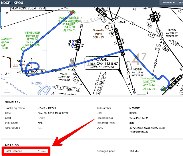
Today, I wanted to pick up the Cirrus from my mechanic after some routine maintenance.  The plan was a VERY simple 24nm flight from Danbury, CT to Poughkeepsie, NY.  You can see the planned route below:
But the weather wasn’t very good … Not terrible, not dangerous, just light rain and low ceilings in both DXR and POU.

Shortly after takeoff, I climbed to ~ 1200 FT and entered the clouds.  From that point on, I found the skies and the NY Approach ATC frequency busier than ever.  Due to other commercial traffic, I got a couple of vectors and reroutes… But eventually, I made it to Poughkeepsie.  where the weather was a little worse than Danbury:
Luckily, POU is a fantastic airport with lots of instrument approaches.  I came in on the RNAV GPS 06, which had an LPV minimums of 503 FT.  Luckily I broke out of the clouds @ ~ 560 FT and was greeted by a runway that was lit up like a Xmas tree!  This turned out to be the perfect real world use case for the amazing Perspective Plus avionics in the new Cirrus!!

You can see what I saw from the cockpit in this short video:

So in the end, the simple, straight 24nm trip, turned into this:
After this flight, I am really starting to feel comfortable with the new avionics!

Stay tuned as I have many more flights/videos coming on My New Youtube Channel !

Cheers,
== T.J.==


Weekend in Grand Cayman

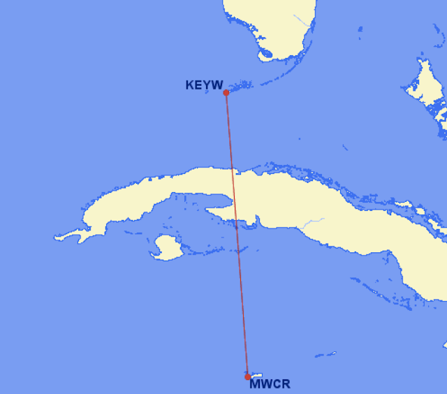
With great weather predicted for south FL and the Caribbean, this past weekend was the perfect opportunity to make a dent in the bucket list.  I decided to fly to Grand Cayman.
The flight was a straightforward IFR route mostly over water and directly over Cuba:
I was a little nervous about the international flying protocol.  While I have done some international flying, this flight would require a  Cuba overflight, which involves getting an explicit permit and some special procedures.

I probably could have done it entirely on my own.  But for added convenience and “peace of mind”, I enlisted the help of the concierge service of Air Journey.  This service is like having a private airline dispatch crew at your disposal.

They provided me an amazing briefing packet prior to the flight, which included everything I needed.  Not only did it include the stuff you would expect, such as charts, flight plan, and International permits, it also included photos of the destination buildings, FBO, customs etc.  With their help, I felt totally prepared.  In addition, it also felt nice to have the “safety blanket” of a knowledgable person to call in the event I encountered something unusual during the journey.
The journey itself was rather simple and very much like flying any IFR flight plan in the US.  However, the ATC radio calls were a bit interesting.  Somehow, the Havana Center controllers seem to know which planes to speak to in English and which ones to speak to in Spanish.  There were also several nuances to international flight that I learned along way.  For example, altimeter usage, Class A airspace boundaries, and reporting points over water in areas with minimal radar coverage.
You can hear some of the ATC audio in the Youtube clip below:

But the views were the most amazing part of the trip.  The color of the water, especially just south of Cuba, was brilliant:
Of course, after a couple of hours over the water, land was certainly a very welcome sight!

Notice the runway edge is right on the water!
Once I landed the immigration/customs process extremely simple and took no more than 5 minutes for the authorities to check my passport and look over the plane.
Within 30 minutes after landing, I was sipping a cool beverage in this hammock on Seven Mile beach!
Cheers,
== T.J.==

Aerobatics Training In a Zlin

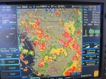
As you have probably noticed, I have not been posting much lately.  It is NOT because I am flying less.  In fact, I have been flying quite a bit lately.  However, most of my flights were routine with nothing that I hadnt posted about before.  But this week, things really started to change!
After finishing the 50 states, I wanted to set a few more (new) goals, which you can see here.
This weekend, I decided was the first step!
I didn’t have all of my international paperwork in order.  So a trip to a new island was out of the question (for now).  But a new aircraft type was totally possible.   With the help of Kathy Hirtz of WingOver Aerobatics, I got to log some VERY interesting time in a ZLIN 242L, which you can see below:

This plane is a 200 hp, aerobatic plane that is capable of pulling +6 Gs and/or -3Gs!
But more importantly, I learned “how to fly” (again)!

Notice the Required Parachute I was wearing!

Aerobatic training was absolutely intense.  I started with a bunch of ground school and learned the intricacies of “hardcore” stick and rudder flying.  You are probably wondering what “hardcore” means in this context…
In “regular” training, which I did years ago, I learned all the basic of flight (pitch, roll, yaw etc) and all of the flight controls that the pilot had at his disposal (power, rudder, aileron, etc).  But with aerobatic training, you MUST learn all of the same material in greater detail and more by “feel” than by numbers on a gauge.
The Zlin was a great plane to learn aerobatics in.  Many aerobatics planes are tailwheels.  But the Zlin is a standard tricycle gear, which makes it a little more comfortable for most pilots to taxi and land.  The Zlin is also the polar opposite of the Cirrus I am accustomed to flying.  Kathy was  repeatedly reminding me to so stop looking at gauges inside the cockpit and focus my attention on “feeling” what the plane was doing outside the cockpit.
I am still not sure I totally understand it, but after a couple of hours, I am starting to get the hang of it!
Kathy was really an amazing instructor!  Despite the numerous mistakes I made in the cockpit, she was totally calm and patient.  So far I know how to do Falling Leafs, Spins, Dutch Rolls, Wing Overs, and (my favorite) the Aileron Rolls.  You can see for yourself how my first lesson in the video below:

Can’t wait for the next lesson, where I will learn how to more advanced maneuvers, such as a Hammerhead or a Cuban 8
Stay tuned for that…
Cheers,
== T.J.==

Migration 9 Trip Summary

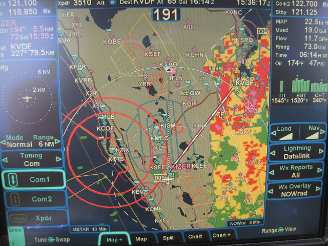
I have finally arrived in Colorado Springs and the journey was quite amazing!

It is hard to summarize a 4200 mile trip.   (But here goes…)

Some of it what was “as expected ” ; Some of it reinforced how flexible you need to be on a journey like this. Between weather, customs formalities, spotty radar, icing, even the exact route was not as planned.  You can see the “planned vs actual” route below:

The blue line was the planned route.  The magenta line was the actual route.  As you can see, I tried to follow my plan.  But needed to make lots of adjustments along the way.
 
On my first leg from Tampa to Hopkinsville, KY, the weather in the picture below forced me to do an enroute diversion to Shelbyville,TN:

I landed and topped off minutes before it started pouring!

After the storm passed, I continued to Sioux Falls, SD where I did my first overnight.
The next day started mostly as planned Sioux Falls,SD > Bismarck, ND > Glasgow, MT.

As I made my final Preparations to enter Canadian airspace, the Canadian authorities (Canpass) informed me that the Kamloops customs was “Closed for the day” So I had to pick an alternate destination and chose Kelowna, British Columbia.

With a new destination, I entered Canadian airspace for the first time to find more surprises. While crossing the Rockies, Edmonton ATC informed me that radar coverage would be “lost over the Rockies”, which was not very comforting!  They gave me a frequency and told me to “try calling Vancouver” in ~ 30-45 minutes.

 
Luckily, the weather was good and of course the view over the Rockies was breathtaking.
(I am still trying to sort through the pix to make a Picassa album.)
 
Kelowna turned out to be a wonderful destination.  The  airport is rather  unique due to the terrain.  It is in a valley, which causes you to fly an unusual approach with a fairly steep descent. (Still working on editing that video)
The next day I flew to Ketchikan, Alaska, which was a very challenging flight.   Canadian ATC instructions/phraseology is just a little different than the US.  But I managed several surprise instructions and even a last minute approach change and had an incredible landing, which is shown in the video below:

After that landing (and enjoying Alaskan hospitality and seafood), I thought that Ketchikan would be the highlight of the journey.  But after a couple of more states, the real highlight of the trip materialized in Leadville, CO.  Lake County Airport in Leadville, CO is the highest airport in North America @ 9927 MSL.  I landed there on a precision approach with a “circle to land” into an 18 KT headwind Gusting to 28 KTs, (Perhaps NOTmy most elegant landing… But certainly  one of the most difficult and satisfying landings I had done in a long time.  
 
As you can see from the pic below, they really do issue certificates for landing there!!

After Leadville, a short 20 minute flight to Colorado Springs and I was warmly greeted by the staff of Colorado Jet Center.  So after this incredible journey, I am now ready for the main event (Migration 9), which is scheduled to start tomorrow morning.
 
Cheers,
== T.J.==

Long X-Country, Weather and State #38 (AZ)

This weekend I had a long cross country flight planned.  The destination was Sedona, AZ, which is a very famous airport for pilots. 

According to the Sedona Airport website, they claim to be “America’s Most Scenic Airport”.  It is also sometimes referred to as the “USS Sedona” because it feels like landing on an aircraft carrier.  This is due to the fact that the airport is situated on a Mesa with a 500 FT dropoff on both ends of the runway. 

To add further drama, Sedona is home to a number of “spiritual vortexes”, which are clearly identified on tourist maps.  In fact, one of them is right on the Airport access road.  Some say that it may even contribute to the bizarre wind patterns that pilots wrestle with on final.
The first leg from Tampa to Shreveport was a grueling battle with weather.  You can see from the screen shot below why I had diversion clearances of 20 degrees right or left most of the way.

Luckily after Shreveport, there was no more rain to contend with.  The next stop was supposed to be Truth or Consequences, NM.  I thought the name was unique, and their runway layout even more unique.  But as I was flying over West Texas, I needed a break.  So I pulled out the iPad and found a great little airport in Snyder, TX that was only 40 miles from my position and had cheap fuel, internet and a crew car!

Since I was on an IFR flight plan, I called ATC and told (not asked) to divert to Winston airport (KSNK).  Their immediate response was “WHY???”.  I replied “NO emergency… Just change in plans”.  Then I did a couple of 360s to get down from 16,000 FT and had an uneventful landing.  The crew at KSNK (Ray and Danny) were extremely friendly and helpful.  After a bite and a bunch of “hanger flying” with the crew, I was ready for departure. 

However, it was 95 degrees out and I struggled with the hot start.  After 2 failed attempts, I pulled up Alex Wolf’s YouTube video on SR22 hot starts and that did the trick. (Thanks Alex!!)

Now I was finally direct Sedona.  As I approached, I instantly understood why this airport has so much hype. The views were breathtaking!  I tried to capture some of it on video, which you can see below:


So Arizona is now officially state # 38 and because of my little detour, I will try to hit New Mexico on the way home.

Cheers,
== T.J.==

Holding Pattern Without A Shuttle View

As everyone knows, today was the day for the space shuttle’s last mission.  I didn’t have tickets to see the launch in person.  But I really wanted to see it.
So I came up with what I thought was a clever plan.  I would fly the Cirrus upto 17,000 FT and go into a holding pattern “near” the launch site.  Of course, “near” meant I had to stay clear of the TFR (temporary flight restriction), which was a 30 mile ring around the launch site.  That would still give me a memorable view and hopefully even some pictures/video.
Unfortunately, this plan didn’t quite work as I had hoped…
The weather in FL was lousy today!  Not as bad as a hurricane or a convective sigmet.  But plenty of clouds, rain and lots of dreary overcast.
Ever the optimist, I filed an IFR flight plan and decided to try it anyway.  I was hoping to get above the clouds where I could get a view.
When I filed the IFR flight plan, I wrote “Training flight: practicing holding patterns @ COKES” in the remarks section.  COKES is an intersection just off the FL east coast near Flagler County airport that was just outside of the TFR.
When I arrived at the airport, I did my preflight inspection under some very nasty looking clouds, which you can see below:
As luck would have it, as soon as I finished my preflight and closed the door, it started raining!

As I waited for my IFR clearance, I watched another Cirrus land in the rain.  I checked all of the avionics one more time and then was ready for takeoff.  Taking off in the rain is bit unusual because there is really not much to see out the window and you have totally rely on instruments moments after rotation.
After I was airborne, the next hurdle was ATC.  They were quite busy today due to the weather and several other aircraft maneuvering to do the same thing as me.  Initially, they only cleared me to 5,000 FT, which was right in the middle of a cloud layer.  Aside from the training/practice value, this was rather unsatisfying.  There was absolutely no view and it was so bumpy I couldn’t even play with any camera equipment.  I asked 3 different controllers for a higher altitude.  Each one told me to “standby” then later said “unable” due to traffic or some other excuse.
Finally, I got handed off to the Daytona Approach control, where I encountered a much more cooperative controller.  Despite my “disguised” flight plan, he knew exactly what I was doing and was eager to help.
He gave me a clearance to 10,000 FT and told me to hold over Ormand Beach Airport.  I happily complied and setup my cameras.  Unfortunately, even @ 10,000 FT, there were too many clouds to see anything.  ATC was unable to clear me any higher due to “inbound international arrivals”.
So after all the effort, I didn’t see or even hear the launch!
But the trip was definitely not over.  I still needed to fly home and the weather continued to add drama to the trip.  You can see both the TFR (with the RED ring) and the weather in Tampa on the screen shot below.

The rain was fairly heavy and I flew the GPS23 all the way down to 450 FT before I could even see the runway!  As I got to the runway numbers, I realized I was a little high.  Since the runway was longer than I needed, I just floated a little and landed slightly long…. You can see for yourself in the video below:
After I got home, I finally watched the launch on CNN…  Even though I didn’t see it live, I got some great weather flying experience today!

Cheers,
== T.J.==

Scenic Trip to Cedar Key

This morning I woke up and  looked outside to find typical weather for FL.  Sunshine as far you could see ; Clear blue sky ; AND a perfect day to go flying!  After my recent CPPP training, I have been sufficiently brainwashed into treating every flight as an opportunity to practice something.

So this morning, I decided to practice short field landings @ Cedar Key Airport, which is a small island airport just west of Ocala.  For a civilian pilot like me, who will likely never get to land on an aircraft carrier, this is as close as I will get.  As you can see in the Google map below, the sole runway  5/23 has water on both ends!

In addition to having a 2300 FT runway, which is short 4 me, they also have NO instrument approaches!  As many of you know, my comfort zone is IFR in Class B airport environments.  So going to Cedar Key was perfect for today!  This gave me a scenic place to fly and gave me some practice outside of my normal comfort zone.

After an uneventful preflight, I departed VFR @ ~ 9AM.  With the music on, I stayed under Tampa’s class B airspace and flew westbound first till I got to the coast.  Then, miraculously without GPS,  I followed the coastline northbound and didn’t get lost!  During the entire journey, I didn’t even talk to ATC!!  

Before attempting Cedar Key, I wanted to practice a landing first on a longer runway.  So I did a “stop and go” @ Crystal River Airport.  The runway there was about double the length of Cedar Key.  Since I handled that with no problem, I felt ready for Cedar Key.

I easily found Cedar Key Airport but felt almost distracted as I approached for landing.  I was trying to concentrate on airspeed and attitude, while I kept getting distracted by sights out the window.  But other than the distractions, the landing was quite easy with calm winds and no surprises. You can see the landing for yourself in the video below:

After I landed and found a place to park, I realized how small the place was.  There is no fuel, no services and only about half a dozen parking spots on the tarmac and a another half dozen in the grass.  I didn’t even see an FBO terminal.  Instead of an FBO, I was greeted on the radio when I was about 5 miles out by a very friendly cab driver/ tour guide named Judy.  She drove her car right up the taxiway and picked me up next to my plane.  

She showed me around the island a bit, which only takes a few minutes because it is so small.  Then suggested a quaint little place for brunch.  After a quick bite, I took off again and circled around the island to get some more pictures before going home.

Cheers,
== T.J.==

Learning New Tricks In Hilton Head

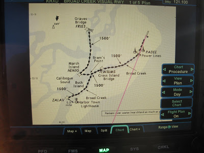
After 300+ hours flying behind the R9 screens, I thought I knew everything there was to know about R9.  But at the risk of sounding like an “old dog”, yesterday at the R9 User Group Meeting in Hilton Head, I learned a couple of cool new tricks!

The weather was excellent and Hilton Head is only 270 miles away… So the plan was for an early morning journey, which would get me there in time for the 08:30 planned start.  The trip there was a rather uneventful flight.  A direct climb to 17k FT using the IAS climb feature of DFC100, followed by a totally peaceful IFR flight.  In fact, the skies were so empty at that hour, that I was making “excuses” to talk to ATC just to ensure that my radio was working properly!

When I got closer to Hilton Head Airport, I checked out the charts and found something unusual.  Instead of the typical cadre of precision approaches,  they had something called the “Broad Creek Visual Approach” procedure.

I had never heard of a “Visual Approach Procedure”.  But it looked rather simple and I was eager to try it.  I asked ATC for a descent and a clearance for this funky approach.  They cleared me “as requested” and told me to “Report when I had the lighthouse in sight”.  Moments later, I saw the infamous lighthouse and proceeded to follow the approach course at 1500 FT along the water.   It was quite a sight following a river at such a low altitude.

I found it quite ironic that in order to get to a user group for a very high tech product, I flew a very old fashioned (and low tech) flight along a river using a lighthouse as a landmark!

After the meeting, I was so excited about the tips, tricks and “gems” that were discussed and was eager to try them myself in flight.

The one “gem” that intrigued me the most, was the idea of a “Pseudo Approach”.  The basic idea is that when flying to any runway (regardless airport ground equipment), you can use R9 altitudes constraints / course offsets in conjunction with the DFC100 Vertical Navigation features to create a simulated GPS approach with a glideslope.  Obviously, this is not a legal FAA sanctioned procedure.  Nor is it as accurate as a real published instrument procedure.  However, when the real thing is not available, it is certainly much better and safer than having nothing. Here is a short video clip that shows my first attempt doing this:

Now after learning a few R9 tricks, I can’t wait till next months’ CPPP training course in Atlanta so I can hopefully learn some cool Cirrus tricks!

Cheers,

== T.J.==