Island Hopping in Hawaii (Part 2)

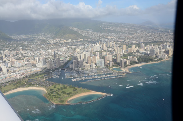
After an exciting intro to island flying, the next couple of days provided more amazing scenery and even more challenging flight conditions.

The first stop, which was the island of Kauai, was the longest flight segment over water.  So we filed a flight plan (and actually used the autopilot a bit).  As we approached the Lihue airport, we decided to fly the ILS 35 by hand just for some practice.  The gusty crosswinds continued to give me quite a workout.  When I was about 200 FT AGL, the winds, which were favoring runway 3, seemed to be getting even stronger (gusting to 35 kts).  The tower noticed this and asked if “I really wanted runway 35?”. I said ” at this point I would prefer 3″.  He agreed and I quickly broke off the approach and circled to the left to land on runway 3.  With a strong headwind lined up straight to the runway I ended up having fairly easy landing.
The next stop was the island of Oahu, which is the most urbanized of the Hawaiian islands. With Laurence’s coaching, I asked ATC for a routing that provided some great photo opps of the Arizona Memorial, Honolulu downtown and Diamond Head.

Honolulu downtown

Diamond Head

I felt very comfortable flying in the Honolulu Class B airspace because there was lots of airline traffic on the radios and it felt just like the East Coast.  But that comfort was quickly replaced by shock as I approached the traffic pattern.  The tower cleared me for a left downwind entry to a visual approach for runway 4L, which they refer to as the  “little” 7000 FT runway.  That sounded easy enough.  But as i got closer I heard the tower clear an airliner for takeoff on runway 08R.
Yikes! This meant my traffic pattern would be just a couple hundred FT directly over an airliner!!
I tried to stay focused… But I really  wanted a picture of this … So I asked Laurence to grab the camera and try to get some photo evidence.  Here’s what he got:

Honolulu airport on approach.

The next day we had a very specific objective, which was to land on the last of the Hawaiian islands to complete my mission and hopefully fly over the active volcano (Kilauea).
There were no significant aviation challenges on this day.  So I was just enjoying the scenery and taking countless pix.  The Big Island actually had a snow covered mountain peak, which took me by surprise.  But the real highlight was seeing the lava flows and overflying Kilauea, which you can see below:

Kilauea volcano

Overall, my Hawaii excursion totally exceeded my expectation and definitely made it onto my Top 10 list!!

Now I am starting to think of the next challenge … Several readers have already sent me suggestions, which I appreciate…

The leading contenders are the Canadian provinces, which might work out nicely this summer, or every country in the Caribbean (except of course Cuba).

Would welcome other creative suggestions!

 
Cheers,
== T.J.==

Island Hopping in Hawaii (Part 1)

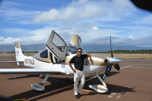
As many of you know, I have been trying to personally land in all 50 states…
After 2 years of flying to every nook and cranny of the continental US and Alaska, this weekend I finally managed to check Hawaii off my list!
The first 49 states were all done in my Cirrus.  However, it just wasn’t practical to fly my plane to Hawaii.    So a few months ago, I started to plan this trip.  I was fully expecting to rent a plane there.  However, I was struggling to find a suitable plane that I would be comfortable enough in for this mission.  Then around December, as a direct result of this blog, I met a fellow Cirrus pilot that had a nearly identical plane to mine based on Maui!  Problem solved!!
The owner was not only a Cirrus pilot, but was also a Cirrus Instructor (CSIP), which really came in handy for this excursion.  (You will understand why shortly)…
When I arrived in Maui, I felt a huge sense of comfort and familiarity when I saw his plane:

N779LB is a 2007 SR22 G3 GTS, that is very similar to my plane.  So the flying part was familiar.  However, this plane was equipped with different avionics.  Since my mission was more about the flying and landing, I let Laurence handle the radios/avionics and I simply did all of the flying by hand.  Absolutely no autopilot… Just old fashioned stick and rudder flying.
But this was a lot more challenging than I expected.  The weather in Hawaii is VFR ~360 days a year.  However, EVERY day seems to involve dodging clouds, rain, terrain and some very unpredictable winds!
On the first day, we took off from Kahalui airport on Maui and went to the neighboring island of Lanai.  The views were spectacular (but somewhat distracting).  This is what I saw out the window while flying on the “right base”:

Then when I was on final ~ 75 FT AGL, the wind shifted from a tame 5 KT headwind to ~ 15 KT crosswind!  While it caught me by surprise, Laurence calmly stated “Happens here all the time – You get used to it…”
I thought that was intense… But that was just a warm up for the next island, which was Molokai.  Here we landed on a tiny strip of pavement, called Kalaupapa, that had the Pacific Ocean just 20 FT off of the departure end of the runway.  The airport had no PAPI lights, no precision glideslope, and none of the normal “crutches” that help me land.  Instead, I had to look out the window and “feel my way” to the runway while fighting a 40KT headwind.  In addition, the runway had ocean waves very close to the edge of the runway.  Being from Florida, I am comfortable flying around water.  But seeing waves like this on approach was a totally new experience!
After a quick photo stop, and an “elegant hot start” by Laurence, we were off to return to home base @ Maui, where we landed in winds of 15, gusting to 24!
Overall, day 1 was only 1.5 on Hobbs… But with the monster winds and using NO autopilot, it felt like quite a workout!
As you can imagine, I also got a ton of amazing pictures… Just haven’t had time time to download and sort through them yet.  That’s why this is only “part 1”
Cheers,
== T.J.==

State #49 (New Mexico) and Vegas

After spending entirely too much time in China during the past month,  I was finally able to squeeze in a good IFR x-country trip.  There was a meeting in Vegas that I wanted to attend and conveniently New Mexico was sort of on the way 😉

The routing was fairly direct, as you can see below:

I could  have done the journey with 2 stops.  But instead, I chose an extra halt so that I could stop @ familiar places where I knew the FBO hospitality was good and the gas was cheap.  Both TVR and DUA fit that purpose.
 
Along the way, the weather was perfect… Well almost perfect… Most of the journey was clear, blue sky.  However, there was one line of ugly weather that I had to cross.  As you can see below, there was just no good way around it.

So I used all of the enroute weather info I could get from ATC, Flight Service and the onboard  R9 weather.  Then I used the vector mode of R9 to dodge and weave through the line.
In the end, I encountered only moderate rain and light chop.
Aside from that brief weather encounter, the rest of the journey till New Mexico was uneventful. 

As far as New Mexico, I wanted to land somewhere in the northern part of the state so that it wouldn’t be too far out of the way.  So I decided to stop @ Tucumcari, NM.  It was a rather spartan airport with quite a bit of construction going on.  But it was still a good rest stop and more importantly the official 49th state! 


After NM, the final leg to Las Vegas turned out to be the truly memorable part of the trip for a couple of reasons.  

First, I was able to fly directly over the Grand Canyon, which is a restricted special flight rules area.  This was due to a friendly ATC controller from Denver Center who was willing to work out a clearance for me.  The views were awesome!  You can see some of the pix in the album below:

The second reason this leg was memorable was the “excitement” of the approach into Las Vegas.  When I was ~ 30 miles out, I requested the GPS 30L approach to North Las Vegas.  ATC was quite busy and basically said “NO… Go Away”.  In fairness, ATC was a bit more polite than that, and since the weather was clear, I was not concerned.  But the troubling part was that ATC wouldn’t give me a clearance to descend until the very last minute.  I was ~ 12 miles away from the airport and still level @ 10,000 FT!
At that point, ATC asked me “IF cleared for the visual approach to 30L via the left downwind, could I make it without having to do a 360″.  With the most confident radio voice I could muster, I said “Affirmative”.  After ATC gave me the official clearance, I pulled the power to idle, applied full right rudder and did what felt like a “nose dive”.  With a descent rate of ~2000+ FT/Min I aimed for the midfield point of the left downwind!
While I have practiced emergency descents before, this was the first time it felt real. I was at idle power almost the entire way to a full stop landing!  Unfortunately, it happened so quickly, I didn’t get a chance to setup the cameras to capture the amazing view of the strip as you land.
In fact, when I was on final, I contemplated declaring a missed approach just so that I could circle around and take some pics… But I decided not to, thinking that might be a bit rude to ATC 😉  
 
Next time, I guess I will need to setup the cameras before takeoff!

Cheers,
== T.J.==

Migration 9 Trip Summary

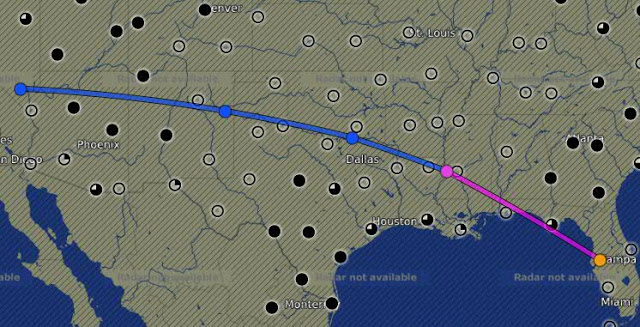
I have finally arrived in Colorado Springs and the journey was quite amazing!

It is hard to summarize a 4200 mile trip.   (But here goes…)

Some of it what was “as expected ” ; Some of it reinforced how flexible you need to be on a journey like this. Between weather, customs formalities, spotty radar, icing, even the exact route was not as planned.  You can see the “planned vs actual” route below:

The blue line was the planned route.  The magenta line was the actual route.  As you can see, I tried to follow my plan.  But needed to make lots of adjustments along the way.
 
On my first leg from Tampa to Hopkinsville, KY, the weather in the picture below forced me to do an enroute diversion to Shelbyville,TN:

I landed and topped off minutes before it started pouring!

After the storm passed, I continued to Sioux Falls, SD where I did my first overnight.
The next day started mostly as planned Sioux Falls,SD > Bismarck, ND > Glasgow, MT.

As I made my final Preparations to enter Canadian airspace, the Canadian authorities (Canpass) informed me that the Kamloops customs was “Closed for the day” So I had to pick an alternate destination and chose Kelowna, British Columbia.

With a new destination, I entered Canadian airspace for the first time to find more surprises. While crossing the Rockies, Edmonton ATC informed me that radar coverage would be “lost over the Rockies”, which was not very comforting!  They gave me a frequency and told me to “try calling Vancouver” in ~ 30-45 minutes.

 
Luckily, the weather was good and of course the view over the Rockies was breathtaking.
(I am still trying to sort through the pix to make a Picassa album.)
 
Kelowna turned out to be a wonderful destination.  The  airport is rather  unique due to the terrain.  It is in a valley, which causes you to fly an unusual approach with a fairly steep descent. (Still working on editing that video)
The next day I flew to Ketchikan, Alaska, which was a very challenging flight.   Canadian ATC instructions/phraseology is just a little different than the US.  But I managed several surprise instructions and even a last minute approach change and had an incredible landing, which is shown in the video below:

After that landing (and enjoying Alaskan hospitality and seafood), I thought that Ketchikan would be the highlight of the journey.  But after a couple of more states, the real highlight of the trip materialized in Leadville, CO.  Lake County Airport in Leadville, CO is the highest airport in North America @ 9927 MSL.  I landed there on a precision approach with a “circle to land” into an 18 KT headwind Gusting to 28 KTs, (Perhaps NOTmy most elegant landing… But certainly  one of the most difficult and satisfying landings I had done in a long time.  
 
As you can see from the pic below, they really do issue certificates for landing there!!

After Leadville, a short 20 minute flight to Colorado Springs and I was warmly greeted by the staff of Colorado Jet Center.  So after this incredible journey, I am now ready for the main event (Migration 9), which is scheduled to start tomorrow morning.
 
Cheers,
== T.J.==

The Scenic Route to M9

As some of you know, this  week is the 9th annual Cirrus migration, known as M9.  While not as big as Osh Kosh or Sun N Fun, it is the biggest Cirrus event of the year.  This year, M9 is being held in Colorado Springs.  Cirrus pilots from around the country (and even a few from other countries) will be by flying their aircraft into KCOS for the event.

I wanted to make the journey to M9 memorable by taking a scenic route to get there.  In addition, this was a great excuse to work on my 50 state quest.  You can see my planned route in the video clip below:

It might be a bit ambitious… But this route should include stops in 7 new states and even a FIRST venture into Canadian airspace!

But every experienced pilot I spoke to about it, warned me that a trip like this requires a few things:
1. Detailed planning about routes, alternate routes, procedures, etc
2. A well maintained and prepared aircraft.
3. Flexibility DURING the flight

As a result, I’ve been planning for weeks…  Looking at lots of charts… Making sure the plane was in perfect shape in terms of maintenance.  Much to the surprise of the line crew in Tampa, I even  made sure the TKS de-ice fluid was full while  it was 95 degrees on the ramp in Tampa!

I am really trying to follow the advice …. We will see at the end of the week how it goes…

You can follow along in near real time on Flight Aware …. Or just wait till later this week to see my next post…(Hopefully I should be able to get some cool pix along the way.)

Cheers,
== T.J.==


State #37 (NE) and Missouri River Flooding

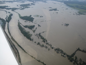
On the way back from Sioux Falls, the weather once again played a factor in my route.  I needed to leave SD before the storms arrived and I was also hoping to hit one more state on the way.
I was heading to Lexington, KY and found a routing through Omaha that worked perfectly:
On the way to Omaha, I noticed a very unusually shaped TFR (temporary flight restriction), which is the red outlined area in the picture below:
At first I wasn’t sure what to make of this …. Then I realized that this TFR was over the sections of the Missouri River that were experiencing some major flooding.  The TFR was surface to 4000 FT.  I overflew most of it and saw how just how bad it was first hand:

Omaha, which is right on the Missouri River near the Iowa border, was also affected by the floods.  The airport was still open despite flooded areas adjacent to several taxiways.
After landing, I jumped into a crew car and headed to the Hollywood Diner.  It was simple, regular diner food.  But it did have some unusual decor.  The whole place is decorated like a 1950s diner with tinsel town memorabilia in every wall, ceiling and corner.

The final leg of the journey was from Omaha to Lexington.  This part of the journey was smooth and uneventful.  Even had a moderate tailwind most of the way.
Cheers,
== T.J.==

The Next State (OK) State #33

The states are now getting further (and harder) …. But that’s OK … Today was a beautiful day to fly… My intended destination was Dallas.  But I was compelled to make a slight detour to land in a new state(Oklahoma).  The route is shown below:
The weather forecast showed a little bit of IFR along my route … But nothing scary.

When I got to the airport, I found the DirecTV blimp was in town for the Bucs game today. When blimps visit, they park right next to my hanger.  Check it out:

Since I needed to do a bunch of Chart/GPS updates anyway, I set the updates running and went to chat with the blimp crew.  Unfortunately, I didn’t plug the plane into external power and apparently I spent too much time gabbing.  By the time I returned, the battery had discharged enough that I couldn’t start the plane normally!  I called the line crew for help and luckily Jose was able to give me a jump start.
After everything was sorted out, I was finally ready to go (total delay ~ 55 minutes).  The delay was not concerning ;  But the fast approaching showers were.  By the time I did my run-up and was really ready to depart, it was raining and the ceilings were dropping fast.  So I picked up my IFR clearance from the ground and took off in the rain.  Here is what the screen looked like right after takeoff:

After bumping along in the rain for a few minutes, I broke out on top of the clouds and it was smooth sailing from that point on direct to HEVVN (pronounced “Heaven”)@ 16k feet.
The HEVVN intersection is a common nav aid that I use over the Gulf of Mexico.  By using this fix, I can stay clear of the international warning areas over the gulf and at the same time stay close enough to land for safety reasons.  Besides it just sounds cool when ATC instructs you to “go direct Heaven”!
As I got closer to my fuel stop in Meridian, I heard a bunch of military traffic on the radio.  There is a lot of military training done around Meridian.  So you usually get to see some cool airplanes in this area.  In particular, today there were 2 T-38s flying formation very close to the traffic pattern.  After I got cleared to land on runway 1, the T-38s asked for permission to do a low pass alongside runway 1.  I was shocked to hear the controller say “approved as requested”!  Seconds after I touched down, the 2 T38s zoomed overhead @ ~ 30 feet AGL and ~100 feet left of centerline.  After passing the runway, they did a near vertical climb and circled around for a full stop on the same runway.
They parked right next to me and I even got to meet them!  I couldn’t get a picture during their low pass, but here they are parked on the tarmac (the 2 gray ones):

They even let me climb up to the cockpit!  See for yourself:
Believe it or not, on the other side of where I parked was an F-18!

After a quick lunch, it was time to move on … I still needed to land in Durant, OK and then get to Dallas.
Rest of the trip was rather uneventful, except for the 60-70 knot headwinds, which seemed like Mother Nature’s way of tormenting me on both legs today!  See for yourself:

Despite true airspeeds in excess of 190 knots, I was frequently traveling at ground speeds a slow as  ~ 120-130 knots.
The stop in Durant, OK was really quite interesting… The airport is right next door to the Choctaw Casino and the FBO is quite memorable… (But it is getting late now and I will have to save that story for another time.)
For now, I am HOPING to ride some huge tailwinds on the home!
 Cheers,
== T.J.==

East Coast Journey (Going Home)

Seven new states, and 5 IMC hours later, it was time to go home.  The journey home involved a stop in Frederick, MD (state #32).  Here is what the final route flown looked like:

Since I needed to stop in MD, it was only natural to stop @ FDK.  I was hoping to squeeze in visit to the AOPA headquarters and also meet a fellow pilot, whose blog I really enjoy.
But getting to FDK was NOT an ez task.  There was a pesky 40-50 knot headwind the whole way there!

Note the 43 Knot headwind on the PFD

But it was a good excuse to use the the new GPS Z approach to runway 23.  I had read about GPS Z approaches, which are the latest/greatest precision WAAS approaches with LPV.  But I had not seen one in person.

Surprisingly, the missed approach goes into the DCADIZ

So that approach led to another soggy landing (and the 4th landing in the rain during this trip!)
But the stop was definitely worth it!  I did get to meet up with a fellow pilot blogger, Toriaflys  If you haven’t checked out her blog yet, I suggest you take a peek (it’s really quite good).
While at Frederick, I also took a tour of the AOPA headquarters.  I already knew what a great organization AOPA was.  However, Silvana Cannon, one of the AOPA staffers, showed me some of the behind the scenes “machinery” that makes this organization tick.  Now I am even more impressed!
After FDK, the trip home should have been rather uneventful.  The weather forecast was very good and hopefully all that IMC was behind me.  I donned the cannula and was cleared up to 16k (where the really good views are)… See for yourself:
The plan was a quick fuel stop @ Homerville, GA and a short final leg back to Tampa.  Unfortunately, the city of Homerville (and it’s mayor) has truly ignored it’s airport.  When I arrived it was an absolute ghost town.  There was not a single person or plane there and they didn’t even have fuel!!  Apparently, the fuel pumps were out of order.  Even the runway was in shabby condition.  But being the eternal optimist that I am, I made “lemonade” out of this lemon stop.  Even though it was deserted and locked, their wireless worked from my Iphone on their front porch.  As a result, I was at least able to catch up on calls/emails in relative comfort.  Then I took a quick 20 mile flight to Valdosta, where I was able to satisfy both the plane’s thirst and my hunger.  Then finally a quick VFR trip home to Tampa:

Mission Accomplished! Just in time for a sunset landing!!

Overall, the journey has really put my piloting skills to the test (both in the air and even on the ground).  Can’t wait to start planning the next batch of states!!!

Cheers,
== T.J.==

East Coast Journey (Day 3)

Avanni (and her parents Ronak & Sapna)

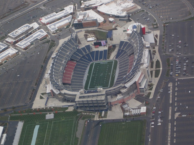
Today was the most varied (and most intense) day of flying I have ever had!  The day began as a leisurely morning sightseeing flight with Avanni (and her Daddy).

As you can see, Ronak got the hang of aerial photography pretty quickly as we flew over Patriots stadium down to Rhode Island and back:

After dropping them back home in Norwood, the drama began.  The first leg was up to Sanford, ME, which was mostly in IMC and light rain.  This landing was state # 29, and involved a GPS approach down to within 300 FT of minimums.
After a quick stop at the cockpit cafe and another weather briefing, I realized I needed to change my route entirely.  Instead of Sanford > Lebanon > Rutland, I ended up going Sanford > Concord > Montpelier.  Weather really forces you to be flexible!  Enroute, was more light rain and total IMC.  This was the view most of the way:

The landing at Concord was another instrument approach to within ~ 300 FT of minimums.  I felt so proud of myself.  (Little did I know what was coming on the next leg!!)
After fuel and another weather briefing, it was time to go Concord > Montpelier.  This involved a flight, where I entered the clouds shortly after takeoff and didn’t see the ground till I was on my final descent.  Aside from being the largest continuous segment of IMC I have done, it also involved an flying an LPV approach all the way down to the published min!  This is what it looked like when I finally broke out of the clouds:

I was soo happy to see the runway!

Other than sunny FL training  days, I have NEVER before flown an approach like that.  (As I result, I know believe that there really is no substitute for “actual IMC”)
The actual route flown so far is shown below:

Upto 31 states now!!

Cheers,
== T.J.==

East Coast Journey (Day 2)

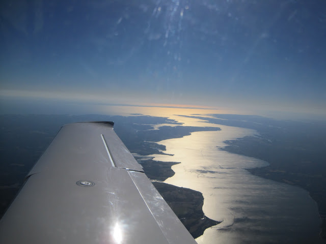
Day 2 was a rather simple day of flying… But it did include 3 new states, unusual ATC interactions, and best of all some awesome sites.
The day began in Raleigh, with another good weather forecast.  I filed IFR RDU > LVL > WWD (Wildwood, NJ) Very simple routing that avoided the Washington DC Special Flight Rules Area.  There were a few cool sites shortly after takeoff:

Some patchy fog in Raleigh during takeoff

Between VA and MD

Webster Naval Base

Then it was time for lunch in Wildwood, NJ (Woohoo state # 26!!!)  Now the ATC excitement begins, I filed an IFR flight plan with what should have been a “preferred” route.  But when I contacted Atlantic City Clearance Delivery, they gave a wild clearance with over 10 fixes and even merging into Victor airways.  The only good news was that the routing was over JFK, which led to some great views of Newark and New York City.

Statue of Liberty through the haze 🙁

NYC from 7000 Ft near JFK

Directly overflying JFK

So after navigating the crazy routing and airways, I tried to do something tricky with ATC.  I asked them if I could do a full stop landing in Westerly, RI, keep my squawk code and immediately take off to Norwood, MA.  While ATC was being very cooperative, they asked me “If I knew the Norwood airport was closed?”
I thought “Yikes” … Better check into it on the ground before showing up.  So after I landed at Westerly, I called the FBO @ Norwood to find out what was going on.  Turns out that they were doing construction on one of the other runways and the airport would reopen with a single runway in operation @ 5PM.  Since I was 30 minutes flight away, I decided to get back in the air and do some sightseeing.  Found a couple of cool airports, which are shown below:

Fishers Island, NY … Looks like an aircraft carrier to me 🙂

Montauk Airport (the very end of Long Island)

After a few good pics (~ 430), I activated an IFR flight plan and headed direct to Norwood.  The timing worked out perfectly, I landed @ 5:03 PM at Norwood, right as they opened!!

Cheers,
== T.J.==